
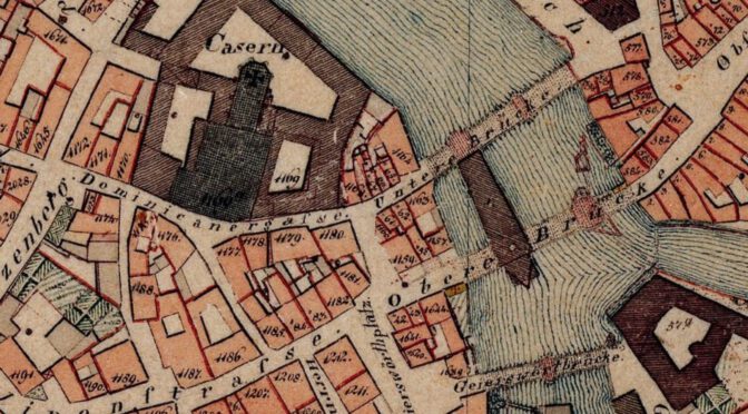
One of my favourite books about historic brewing in Bamberg is Das Bamberger Bier from 1818. It comes with an appendix that lists all the breweries at the time, including the name, their owner, the district, and the house number. Ron Pattinson published a digitalized version of that list.
Recently, as part of final research for my next book, I stumbled upon a historic map of Bamberg that also happened to include house numbers. Unlike modern numbering, houses back then weren’t just numbered by street, but had a unique number within the city, which makes it harder to associate historic addresses with modern ones. I did remember that the above-mentioned book contained house numbers, I looked up a few, and lo and behold, they actually matched.
My initial plan was to just send Ron an email with a few corrections, but very quickly I realized that I should turn these into a proper map, not just for myself, but for everyone to look at. And that’s what I did:
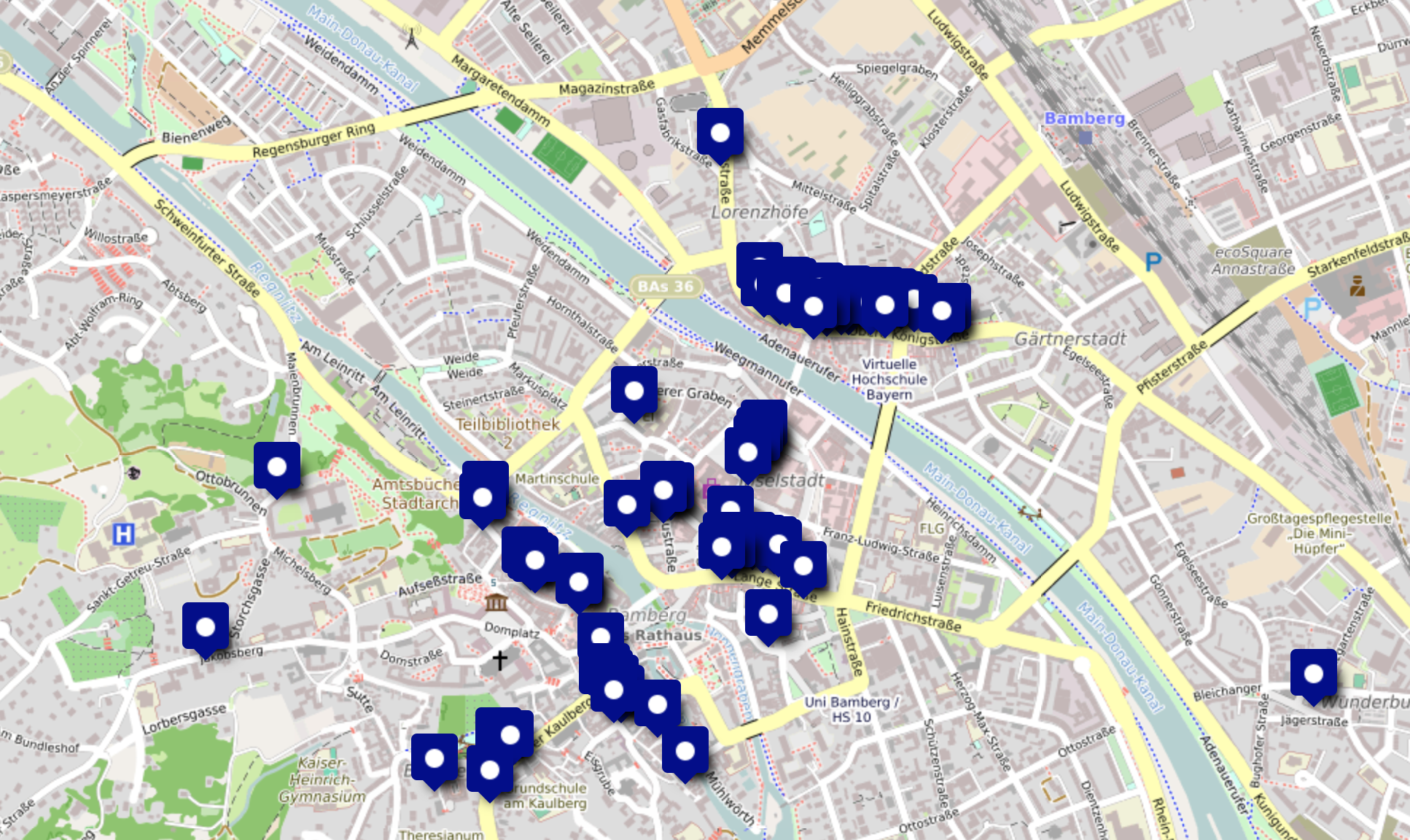
I created this map using uMap, an OpenStreetMap-based tool to create your own custom maps. Here’s a link to my map Historic Breweries of Bamberg.
When I created this, certain patterns became apparent very quickly. The 65 breweries were not just spread out over the city, but they formed clusters.
If you’ve ever been to Bamberg, you may remember how the breweries Spezial and Fässla are opposite of each other. This is not a happy accident, but rather a remnant of basically one big street full of breweries. Only these two breweries remain nowadays, back 200 years ago, the road that was then called Steinweg and is nowadays Untere and Obere Königstraße was home to a whopping 21 (!!) breweries, spanning over just ~400 metres. Bear in mind that the whole city had 65 breweries, so basically a third of them were on the same street, within a few hundred metres of each other.
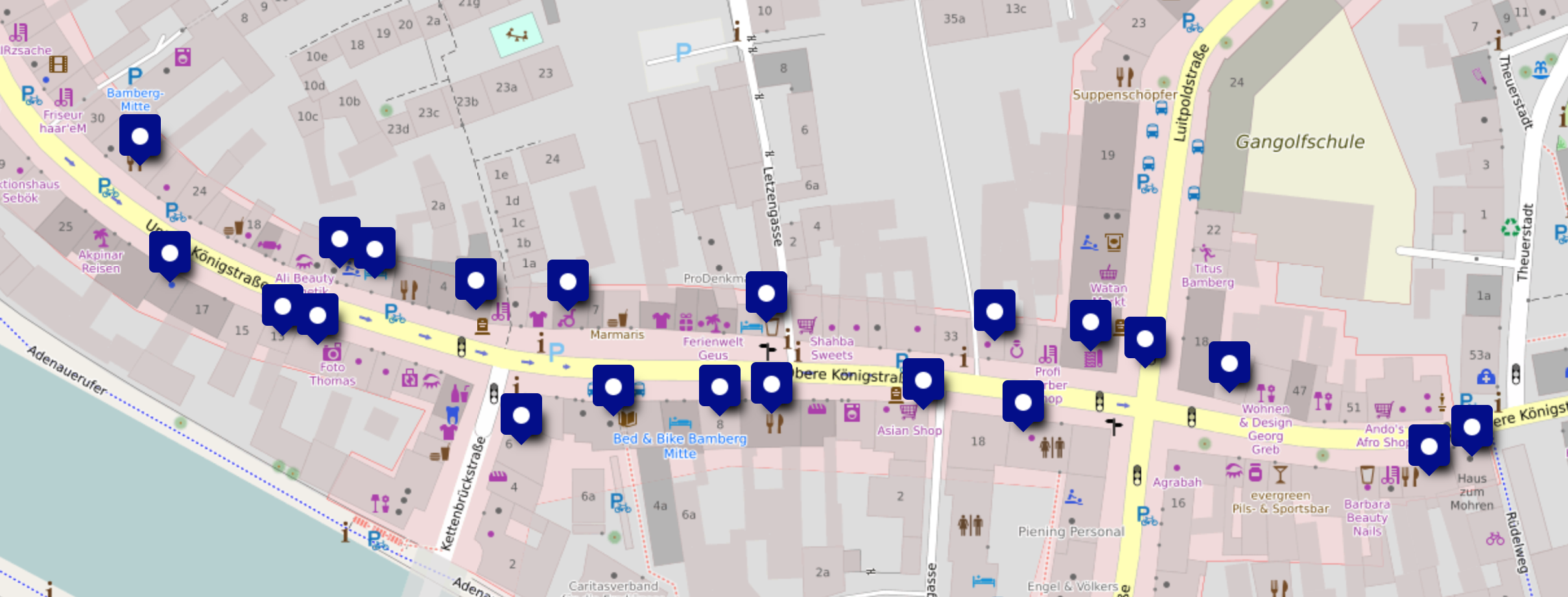
I have no clue what it was that attracted this many breweries to just a single road. Maybe the quality of the well water, the vicinity to the Regnitz river, or the social acceptance of smelly breweries on that one street? I don’t know, all I can do is wildly speculate. It nevertheless was something fascinating to see, information that you wouldn’t just get from a list of breweries and their respective house numbers.
It certainly makes me wonder how it would have been to wander around there 200 years ago…
Other notable clusters of breweries in Bamberg that I won’t discuss in detail are:
- Judengasse (modern Judenstraße), with 6 breweries within ~60 metres,
- Lange Gasse (modern Lange Straße), with 8 breweries on a street, all within about 100 metres,
- The east-south-eastern side of Maximiliansplatz and a bit of Hauptwachstraße, with 4 breweries,
- A total of 5 breweries on Obere Sandgasse to Dominikanergasse, basically from Zum Einhorn im Sand (modern-day/revived Ahörnla) to Zum Heller (the modern-day Schlenkerla pub).
I hope this map will also be useful to others. It is by no means a complete map of all (historic) breweries in Bamberg, but it should accurately reflect the state of the year 1818.
Here’s what I used to research this:
- Historic maps of Bamberg on BayernAtlas
- Historische Brauereien in Bamberg
- An 1876 Bamberg address book
- Ron’s digitalization of the 1818 list of breweries
One caveat, though: the house number for “Zum Stern” in the source is 126. Modern Sternla is on the same street, but further down. The name would suggest that this is the same entity, but I have not been able to verify that, hence why I put the marker for “Zum Stern” on house 126 and not house 144 (modern-day Lange Straße 46).
Considering the historical fire risk it would make sense locating many breweries (via regulation) close to each other and situating existing firefighting capabilities nearby.
Yes, that would be a valid concern. I actually found a book about brewing in Bamberg just yesterday that explains it more in detail, as well as the concentration of breweries on one street.
Essentially, all the breweries were there because the road was the direct connection to Nuremberg, so any travelers coming from Nuremberg and passing through Bamberg would end up on that street, so lots of inns, and a lot of them were also breweries (possibly all of them; the book says that while Bamberg had 60+ breweries, it only had 10 licensed pubs that bought their beer from other breweries). This changed when Bamberg got connected to the railway network, and was one factor why more and more breweries on that road were closing.
As for the fire protection aspect, that was actually something taken into account in how the buildings were designed: often, maltings and brewery itself were in separate buildings out in the back. Malting was not a separate business yet, and all brewers also made their own malt.
Wonderful. Thanks for adding!
also see https://www.bambergbeerguide.com/polarbear.php
and https://www.bambergbeerguide.com/sandstrasse.php
RIP Fred