Tag Archives: map

More Details about Keesmann and Mahr, A New Little Mystery Around Schlenkerla

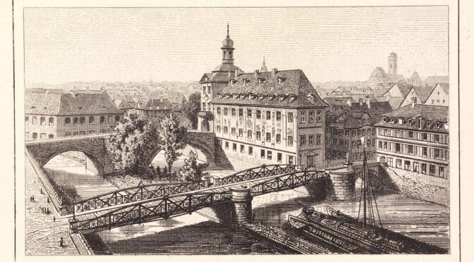
I couldn’t let go of the little mystery of Keesmann and Mahr that I had come across recently: an 1876 address book of Bamberg and the surrounding area connected the two breweries as both belonging to “Brenner” brewery. The brewery nowadays known as Mahrs Bräu in the Wunderburg area of Bamberg used to bear exactly that name and was commonly known as “Zum Brenner” already in a book about brewing in Bamberg from 1818.

A second little mystery was that I had found the name “Ambros Mahr” in two contexts: once in connection with “Zum Brenner” at Wunderburg, and once as liqueur and vinegar manufacturer on Dominikanergasse, in the building of modern-day Ambräusianum, and I was wondering whether these were the same person or two different ones.

Let’s start with the second mystery first: I searched for the name in the city archive of Bamberg, and even though I wasn’t able to get full files (nothing digitized yet other than the catalogue and some photos, it seems), I found that there exists a marriage document for “Mahr Ambros, Bierbrauer” from 1864 and another marriage document for “Mahr Ambros, Liqueurfabrikant” from 1869. To me, the impression is that these are two different persons, not only because of two marriages in distinct years but still close together, but also because the profession is mentioned in addition to the name.

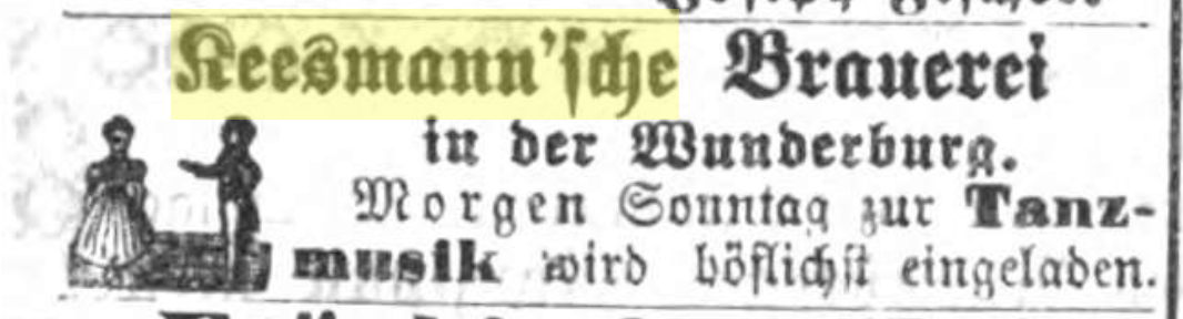
When it came to a possible connection between Keesmann and Mahr, this wasn’t quite as easy. One thing I noticed was that Keesmann was generally referred to “Keesmann’sche Wirthschaft” (meaning something like “Keesmann’s public house”) before November 1867, but starting in that month, mentions of “Keesmann’sche Brauerei” (Keesmann’s brewery) also start appearing. The term “Wirthschaft” is still being used later on. 1867 matches up exactly with the “official” foundation date of Keesmann brewery. In later years, it becomes very obvious that Keesmann is most definitely a brewery: Georg Keesmann is listed with the profession “brewer” as candidate for the fourth election district of Bamberg in 1869, while in previous elections, his profession was still “Wirth” (publican).

The earliest mention of Keesmann as a brewery, from Nov 23, 1867. “Keesmann’s brewery at Wunderburg, cordially invites to dance music tomorrow Sunday.”

Some evidence that Mahrs and Keesmann were not actually connected can be found in advertising: both Ambros Mahr and Adam Keesmann posted competing invitations to celebrate “Nachkirchweih” (a Kirchweih is the celebration of a church anniversary, often in the form of a fair, so a Nachkirchweih seems to be an after-party to that) in 1877 with similar offerings: both advertise Harmoniemusik (small ensembles of wind instruments), Krapfen, coffee and beer (Lagerbier at Mahr, Doppelbier at Keesmann), with Mahr also offering roast goose, duck and kid goat as food, while Keesmann only says “warm and cold dishes”. Harmoniemusik, Krapfen and coffee seemed to have been a standard offering as Murrmann, another brewery on the other side of the city, was also offering these in addition to roast venison.

Murrmann, Mahr and Keesmann all advertising Nachkirchweih celebrations, Aug 2, 1877.

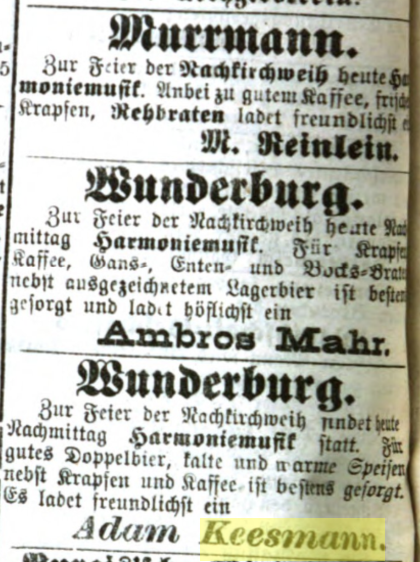
While this is in no way conclusive, I still have not been able to find a second source that would associate Keesmann with Mahr or “zum Brenner” in any way. So the whole thing might as well just be a misunderstanding or a plain mistake in the 1876 source.

During my research, I also found a most likely incomplete list of beer cellars in Bamberg from 1834, in the tourist guide book Bamberg und seine Umgebungen. These were probably just the ones serving customers directly at the Keller and thus worth mentioning. It still delivered some interesting insight.

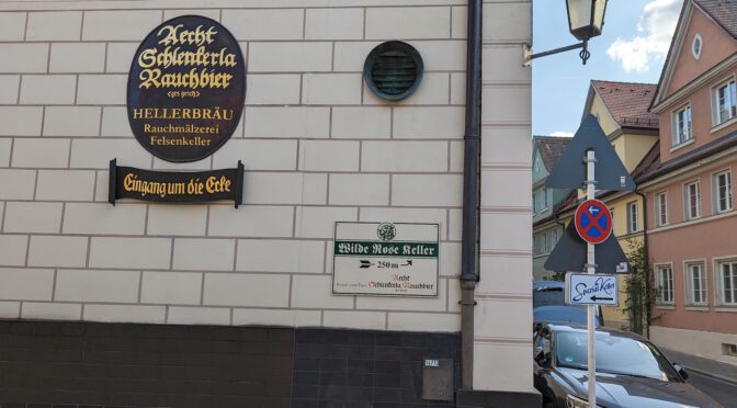
As most people who spent a beery time in Bamberg have probably noticed, the brewery/lagering cellar of Schlenkerla (Brauerei Heller) is on Oberer Stephansberg. It’s very hard to miss if you walk up to Wilde-Rose-Keller or take a left turn to Spezial-Keller.

So, the thing is, the 1834 source does not actually locate the Heller cellar in that building. The closest one to it is the cellar of Jäck, which is either part of or directly adjacent to the modern Heller building. Instead, the Heller cellar used to be located on Oberer Kaulberg, on modern-day Laurenzistraße, not too far away from Greifenklau. Schlenkerla’s official chronicle on their website mentions that when Johann Wolfgang Heller purchased the brewery, a “rock cellar on the highest Kaulberg” belonged to it.

Still, it’s not clear when the brewery even moved cellars: the brewery’s history page only mentions that the Schlenkerla beer cellar at Oberer Stephansberg was closed down in the 1920s for economic reasons, and that a new brewery building was erected in its stead in 1936. But that still leaves a gap of about 90 years where Brauerei Heller must have moved cellars. I will keep on researching.

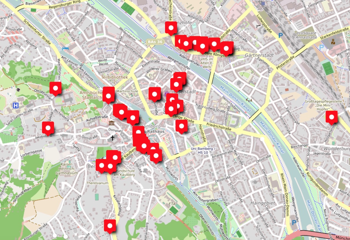
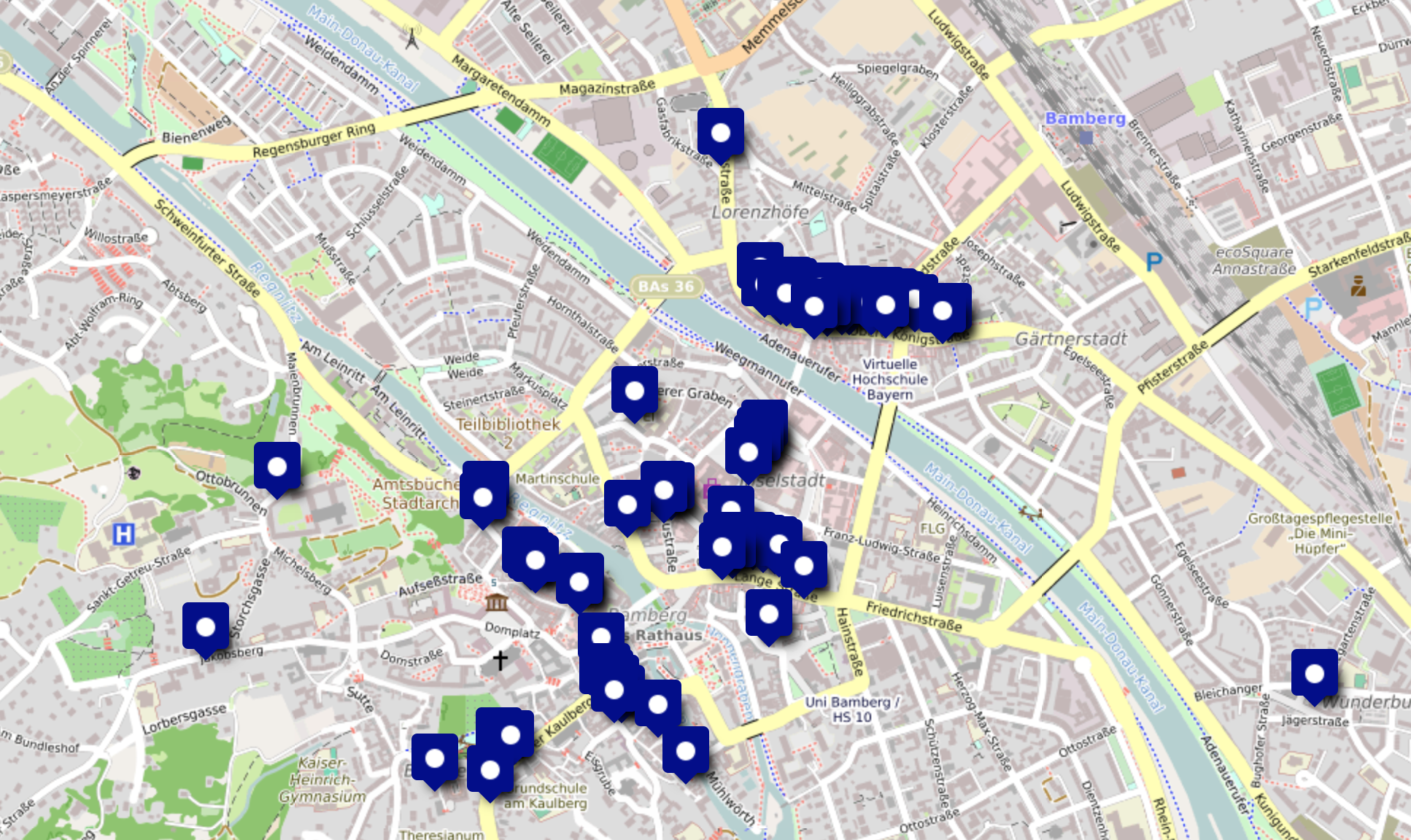
In any case, I added the 1834 source to my map of historic breweries of Bamberg, as a third layer.

Historic Breweries of Bamberg, 1876

Back in July, I put in some effort into mapping the historic breweries of Bamberg as of 1818. Today, I added a second layer to the same map that now contains all the breweries of Bamberg as of 1876, at least according to an address book of Bamberg from that year (like last time, I used this historic map to identify the specific buildings by building number).

map data © OpenStreetMap contributors under ODbL

This allows for an easy comparison of the data from 1818 and 1876, and it shows a trend: of the 65 breweries of 1818, only 41 breweries remained. It was a time of industrialisation and rationalisation, so some breweries were merged, others just closed down. Most of the culling seem to have happened on Steinweg (modern Obere/Untere Königstraße): of the 21 breweries in 1818, only 8 still existed in 1876. One brewery appears new on the map, Zum Goldenen Löwen, but it looks like the brewery of the same name that was previously located at Holzmarkt simply moved to a different building on Steinweg.

It wasn’t much better on Lange Gasse (modern Lange Straße), another cluster of breweries: of 8 breweries in 1818, only 2 remained.

The 1876 address book also cleared up a confusion I had with the 1818 source: the 1818 book lists “Zum Stern” at building 126, even though the brewpub “Zum Sternla” is located in building 144. In the 1876 book though, building 126 is listed as the brewery “Stöhr”, while “Stern” is listed as building 144 (not as a brewery though, only as a pub). To me, that just looks like a transcription error, where the author probably incorrectly wrote down “Stöhr” as “Stern”.

Other breweries seem to have moved: Mohrmann/Murmann (the latter is the 1876 spelling) moved a few houses up the street, Riegelhof brewery is listed at a different address two blocks up the street on Unterer Stephansberg (modern Concordiastraße), and Brenner brewery (modern Mahrs Bräu) seemed to have been in an entirely different building down the road, while the building of where Mahrs Bräu is located nowadays was only listed as a pub.

Talking about Mahrs Bräu in Wunderburg, I came across something strange: the Mahr pub (building 702) is listed as “Brenner” with owner Ambros Mahr, while the “Brenner” brewery is listed with owner Karl Mahr (building 736½ on modern Holzgartenstraße, probably no. 29). But there is a second pub with the name “Brenner” listed, building 708, across the road from Ambros Mahr’s pub, with owner Adam Keesmann. Interestingly, Keesmann is not listed as a brewery (it was officially founded in 1867), and I still don’t understand the supposed connection of Keesmann and Mahr.

Georg Keesmann, the person most often mentioned these days in connection with the foundation of Keesmann brewery (he was a butcher and allegedly finished his brewing education at age 51 to start his own brewery), is listed as a restaurant owner in a different section of the address book, not a brewery owner, for building 708. How are Georg and Adam related? At least based on that data, it looks Georg was running the restaurant, while Adam was running the brewery, both located in the same building. But why it is listed as “Brenner” is entirely unclear.

Interestingly, an Ambros Mahr is also mentioned as a liqueur and vinegar manufacturer, but in a completely different building, 1172, where modern Ambräusianum brewery is located. Is this the same person as the one listed for the “Brenner” pub, or a different one? On another page, the address book lists the brewery owner Ambros Mahr separately from the liqueur manufacturer Ambros Mahr, so that doesn’t exactly clear that up.

In any case, it shows that things were more complicated, breweries, pubs and restaurants were a bit more fluid, and not every historic brewery that still exists these days was always located in the same building. And most certainly, more research into the history of Keesmann seems necessary.

Mapping Historic Breweries in Bamberg

One of my favourite books about historic brewing in Bamberg is Das Bamberger Bier from 1818. It comes with an appendix that lists all the breweries at the time, including the name, their owner, the district, and the house number. Ron Pattinson published a digitalized version of that list.

Recently, as part of final research for my next book, I stumbled upon a historic map of Bamberg that also happened to include house numbers. Unlike modern numbering, houses back then weren’t just numbered by street, but had a unique number within the city, which makes it harder to associate historic addresses with modern ones. I did remember that the above-mentioned book contained house numbers, I looked up a few, and lo and behold, they actually matched.

My initial plan was to just send Ron an email with a few corrections, but very quickly I realized that I should turn these into a proper map, not just for myself, but for everyone to look at. And that’s what I did:

map data (c) OpenStreetMap contributors under ODbL

I created this map using uMap, an OpenStreetMap-based tool to create your own custom maps. Here’s a link to my map Historic Breweries of Bamberg.

When I created this, certain patterns became apparent very quickly. The 65 breweries were not just spread out over the city, but they formed clusters.

If you’ve ever been to Bamberg, you may remember how the breweries Spezial and Fässla are opposite of each other. This is not a happy accident, but rather a remnant of basically one big street full of breweries. Only these two breweries remain nowadays, back 200 years ago, the road that was then called Steinweg and is nowadays Untere and Obere Königstraße was home to a whopping 21 (!!) breweries, spanning over just ~400 metres. Bear in mind that the whole city had 65 breweries, so basically a third of them were on the same street, within a few hundred metres of each other.

map data (c) OpenStreetMap contributors under ODbL

I have no clue what it was that attracted this many breweries to just a single road. Maybe the quality of the well water, the vicinity to the Regnitz river, or the social acceptance of smelly breweries on that one street? I don’t know, all I can do is wildly speculate. It nevertheless was something fascinating to see, information that you wouldn’t just get from a list of breweries and their respective house numbers.

It certainly makes me wonder how it would have been to wander around there 200 years ago…

Other notable clusters of breweries in Bamberg that I won’t discuss in detail are:

  • Judengasse (modern Judenstraße), with 6 breweries within ~60 metres,
  • Lange Gasse (modern Lange Straße), with 8 breweries on a street, all within about 100 metres,
  • The east-south-eastern side of Maximiliansplatz and a bit of Hauptwachstraße, with 4 breweries,
  • A total of 5 breweries on Obere Sandgasse to Dominikanergasse, basically from Zum Einhorn im Sand (modern-day/revived Ahörnla) to Zum Heller (the modern-day Schlenkerla pub).

I hope this map will also be useful to others. It is by no means a complete map of all (historic) breweries in Bamberg, but it should accurately reflect the state of the year 1818.

Here’s what I used to research this:

One caveat, though: the house number for “Zum Stern” in the source is 126. Modern Sternla is on the same street, but further down. The name would suggest that this is the same entity, but I have not been able to verify that, hence why I put the marker for “Zum Stern” on house 126 and not house 144 (modern-day Lange Straße 46).